Vantor Launches WorldView 3D to Deliver Up-to-Date 3D Ground Truth for Mission-Critical Operations Anywhere on Earth
Vantor, the leading provider of spatial intelligence from space to ground, today announced the launch of WorldView™ 3D, a first-of-its-kind satellite tasking product line that gives warfighters, int...
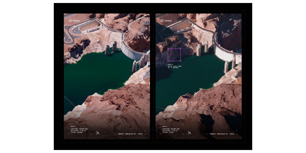


First-of-its-kind satellite tasking product delivers highly accurate 3D maps within 24 hours to power autonomous systems, tactical operations, intelligence analysis, and digital mapping
WESTMINSTER, Colo.: Vantor, the leading provider of spatial intelligence from space to ground, today announced the launch of WorldView™ 3D, a first-of-its-kind satellite tasking product line that gives warfighters, intelligence analysts, and mapmakers an up-to-date 3D ground truth layer for missions that depend on an accurate model of the physical world.
WorldView 3D empowers customers to task and receive updated 3D data anywhere on Earth within 24 hours of image collection, with timelines often closer to six hours. Customers can also produce higher-definition 3D maps with extreme detail for missions that require greater fidelity.
3D maps are now the foundational operating layer for a wide range of missions, from GPS-denied autonomy and tactical operations to intelligence analysis and real-time mapping. They provide humans, autonomous systems, and physical AI with the accurate spatial context needed to understand, navigate, and act in the real world.
But the physical world is changing faster than traditional 3D mapping cycles can keep up. Conflict, natural disaster, and rapid urban change can quickly make static maps out of date. For decades, organizations have updated their 3D maps using aircraft and drone collection programs, which are often costly and difficult to scale across remote or contested areas.
For the first time, WorldView 3D closes that gap by giving users the ability to rapidly build updated 3D maps from space, transforming the speed and scale of deploying an accurate ground truth. It is also a critical capability for delivering the operational terrain, or a continuously updated 3D view of the physical terrain that is easily understood by both humans and autonomous systems.
“WorldView 3D sets a new standard for how customers maintain command of the ground truth and decision advantage in a fast-changing world,” said Peter Wilczynski, Chief Product Officer at Vantor. “From command and control to autonomous systems operating in GPS-denied environments, many of today’s most complex missions require current, accurate 3D terrain. With WorldView 3D, customers can update the specific areas they care about, including remote and contested areas where traditional aircraft collection is limited, with unmatched speed and scale. This is the future of spatial intelligence.”
WorldView 3D integrates Vantor’s satellite tasking capabilities, AI-powered production software, and trusted 3D spatial foundation-which includes more than 100 million square kilometers of the world mapped at GPS-level accuracy-to deliver updated terrain at the speed of change.
The product is available through two options designed for different mission needs:
- Rapid 3D: Designed for time-sensitive missions where terrain conditions can change quickly, this product delivers updated 3D terrain within 24 hours of image collection with just a single satellite pass. Accessible via Vantor™ Hub, it delivers 50 cm-class resolution and 4 m accuracy in all dimensions.
- High-definition (HD) 3D: Designed for missions that require greater fidelity, this product provides detailed 3D maps at 15 cm resolution and 3 m accuracy in all dimensions. Available globally on a project basis, this capability can also be delivered through change-based refresh subscriptions for customers who need to monitor terrain and infrastructure over time.
WorldView 3D is the latest product extending the capabilities of Vantor’s Tensorglobe™ spatial intelligence platform, which integrates the company’s imaging satellite constellation, trusted spatial foundation, and operational software to drive the full intelligence cycle from tasking and production to analysis and delivery.
Learn more here.
About Vantor
Vantor is forging the new frontier of spatial intelligence, empowering nations and global businesses with the power to command the ground truth from space to ground. We integrate our trusted intelligence, sovereign control, and AI-powered capabilities to build a unified picture of what’s happening on Earth and in space. Fueled by the Vantor imaging satellite constellation, Vantor’s Tensorglobe platform orchestrates the full spatial intelligence cycle-from tasking and fusion to analysis and delivery-anchoring real-time data from space, air and ground to Vantor’s uniquely accurate, AI-ready spatial foundation. With this combination of hardware, data, and operational software, Vantor supports the missions that matter most, from real-time mapmaking and GEOINT analysis to tactical operations, persistent monitoring and autonomy. Learn more at www.vantor.com.
Fonte: Business Wire
Related news

Last News
RSA at Cybertech Europe 2024
Alaa Abdul Nabi, Vice President, Sales International at RSA presents the innovations the vendor brings to Cybertech as part of a passwordless vision for…
Italian Security Awards 2024: G11 Media honours the best of Italian cybersecurity
G11 Media's SecurityOpenLab magazine rewards excellence in cybersecurity: the best vendors based on user votes
How Austria is making its AI ecosystem grow
Always keeping an European perspective, Austria has developed a thriving AI ecosystem that now can attract talents and companies from other countries
Sparkle and Telsy test Quantum Key Distribution in practice
Successfully completing a Proof of Concept implementation in Athens, the two Italian companies prove that QKD can be easily implemented also in pre-existing…
Most read
Arca Raises $64 Million to Revolutionize and Humanize Wealth Management…
Arca, an AI-native wealth management company that brings personalized, advisor-led financial services, today exited stealth and announced it secured $64…
Capco Recognized by OpenAI for Innovation and Responsible AI Leadership
Global management and technology consultancy Capco, a Wipro company, has been recognized by OpenAI for both AI innovation and responsible AI leadership.…
TensorX Launches With €8M Seed Funding Round Led by Darius Cubed Ventures…
A team of Irish founders has committed €8 million to Nvidia Blackwell GPUs, including the latest B300 chips, to launch TensorX, a sovereign AI inference…
Gina Raimondo and Eric Holcomb Launch RAISE US, Uniting the Nation’s Leading…
Gina Raimondo, the 40th U.S. Secretary of Commerce and 75th Governor of Rhode Island, and Eric Holcomb, the 51st Governor of Indiana, today launched RAISE…
G11 Media Networks
InnovationOpenLab is a channel of BitCity, a newspaper registered at the court of Como ,
n. 21/2007 del
11/10/2007- Registration ROC n. 15698
G11 MEDIA S.R.L.
Registered office Via NUOVA VALASSINA, 4 22046 MERONE (CO) - P.IVA/C.F.03062910132
Como business register n. 03062910132 - REA n. 293834 CAPITALE SOCIALE Euro 30.000 i.v.
